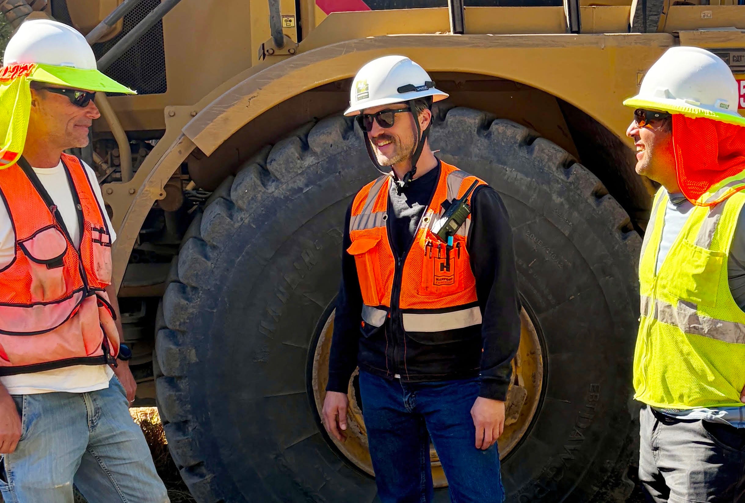
The heavy equipment is back on Green Valley Creek. Just upstream from last year’s salmon restoration at Iron Horse Vineyards, three excavators, dump trucks, a water truck, and a crew of hand laborers are reshaping another stretch of the floodplain so that juvenile coho and steelhead have a place to go when winter storms turn the creek into a torrent.
The work is the second phase of a long-running effort led by the Gold Ridge Resource Conservation District (Gold Ridge) and funded by the California Department of Fish and Wildlife and the National Oceanic and Atmospheric Administration (NOAA) Restoration Center. PCI Ecological, the Sebastopol firm that designed the Iron Horse project, again provided the engineering design and is overseeing construction.
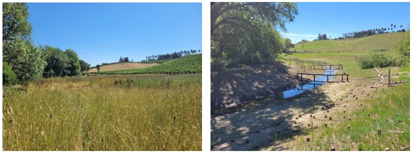
“What we’re doing here is not that different,” says John Green, Gold Ridge’s self-effacing lead scientist and program manager, standing at the edge of a freshly carved side channel. “The goals are very similar. It’s just that the configuration of the project fits what was already here.”
The two projects sit side by side, both immediately downstream of where Atascadero Creek meets Green Valley Creek. That location is no accident. As Green describes it, it is one of the richest feeding grounds for young salmon anywhere in the Russian River watershed. This project is known as the Lower Green Valley Creek Confluence Reach project.
The first winter: fish showed up right away
Before talking about the new site, I wanted to talk about the Iron Horse project, because the two are almost physically connected.
Construction at Iron Horse wrapped up in early November last year, including erosion control. Crews planted native vegetation in November and December, and the first rains followed soon after. In late November, Gold Ridge installed monitoring equipment at the lower end of the site: an array of PIT tag antennas.
PIT stands for passive integrated transponder. The tiny chips are implanted in a share of the hatchery-raised juvenile coho released into the watershed, each with its own ID number. When a tagged fish swims past an antenna, the array records which fish it was and when it passed.
“In early December, when the creek came up, we immediately had fish using our newly constructed features,” Green says. “And that continued all through the winter and the spring.” The antennas logged a steady stream of tagged coho moving through the side channels and floodplains built only weeks earlier.
For Green, that quick response was the proof that mattered. “Seeing fish come in and use that immediately and then continue to use it all through the winter, to me says, okay, this is exactly what they were looking for.”
The creek did rearrange itself a little after the high flows: some scour on a bank, a bit more scour beneath one of the log structures. Green, a geomorphologist by training, sees that as a sign of health, not trouble. “When I see that, I’m like, cool, this is what creeks do. They change their bed and banks. They move sediment.”
The plantings have held up as well, even through a long, dry season with almost no rain since May. “The larger plants -- shrubs and trees -- have been irrigated and will continue to be for the next couple of years. The forbs* and grasses go dormant or die back in the summer,” Green says. “I consider that project to be an enormous success.”
Laurence and Joy Sterling, the owners of Iron Horse Vineyards, agree. They were enthusiastic from the start, Green says, and are even more so now. Gold Ridge made them a storyboard of the project, which now hangs in the winery’s tasting room.
Why this stretch of creek matters
Green Valley Creek has long been considered critical habitat for coho and steelhead. The upper creek and its tributary, Purrington Creek, are where the fish spawn. When winter rains raise the water, young fish start migrating downstream and arrive at a stretch of creek fed by the Atascadero wetlands.
Atascadero is a large wetland complex, and it produces enormous numbers of insects. The current carries them down into Green Valley Creek. “The fish can hang out here or go up in the lower Atascadero and just feast,” Green says. “They get here, and I think they’re like, ‘Why would I go any farther? There’s a ton of food here.’”
The results show up in the fish themselves. Juvenile salmon leaving Green Valley Creek are often twice as large or more as those from any other tributary of the Russian River. Fish from other streams even travel up into Green Valley to feed through the winter before heading out to sea in the spring.
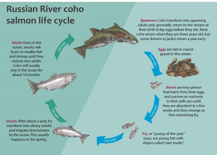
Size matters a great deal. “There’s a strong correlation between the size of a juvenile fish when it enters the ocean and whether it makes it back in two years to spawn,” Green says. “The bigger they are, the better chance they’re going to make it back.”
But a buffet is only useful if the fish can stay at the table. For much of the last century, they couldn’t.
A century of straightening the creek
The problems at the Phase 2 site are the same ones the Iron Horse project set out to fix, and they have the same history.
Over the past 150 years or so, Green explains, settlers saw the creek’s bottomland as prime farmland. They cleared side channels and filled in wetlands so they could farm right up to the bank. At the same time, logging and development in the upper watershed sent huge quantities of sediment downstream, filling the now single-thread channel.
As the channel filled, floods followed, and people tried to lessen the impact by dredging. That happened repeatedly, Green says, from roughly the 1920s or 1930s into the 1980s, though records are thin. The result was a simplified channel, deep and narrow, where water moves fast.
The floodplain still floods. “It’s not unusual for the place where we’re sitting right now to be knee-deep in water during the winter,” Green says. Fish can be swept out onto it, but without defined side channels to give them a flow signal, they have trouble finding their way back to the creek.”
The fix follows the Iron Horse model. Crews are cutting side channels and shaping the floodplain to create slow, low-velocity water where young fish can rest during high flows and feed on drifting insects. As at Iron Horse, the channels are designed to connect with the creek at different water levels, mimicking the pulse of a natural system.
Large wood is a key part of the design. Logs provide fish cover from predators and create scour patterns that help keep the side channels from silting closed. Green picks up a steel rod about an inch thick, threaded along its length. “We use this stuff to bolt our wood structures together,” he says. Crews drill through the logs, run the rod through, and bolt it at both ends.
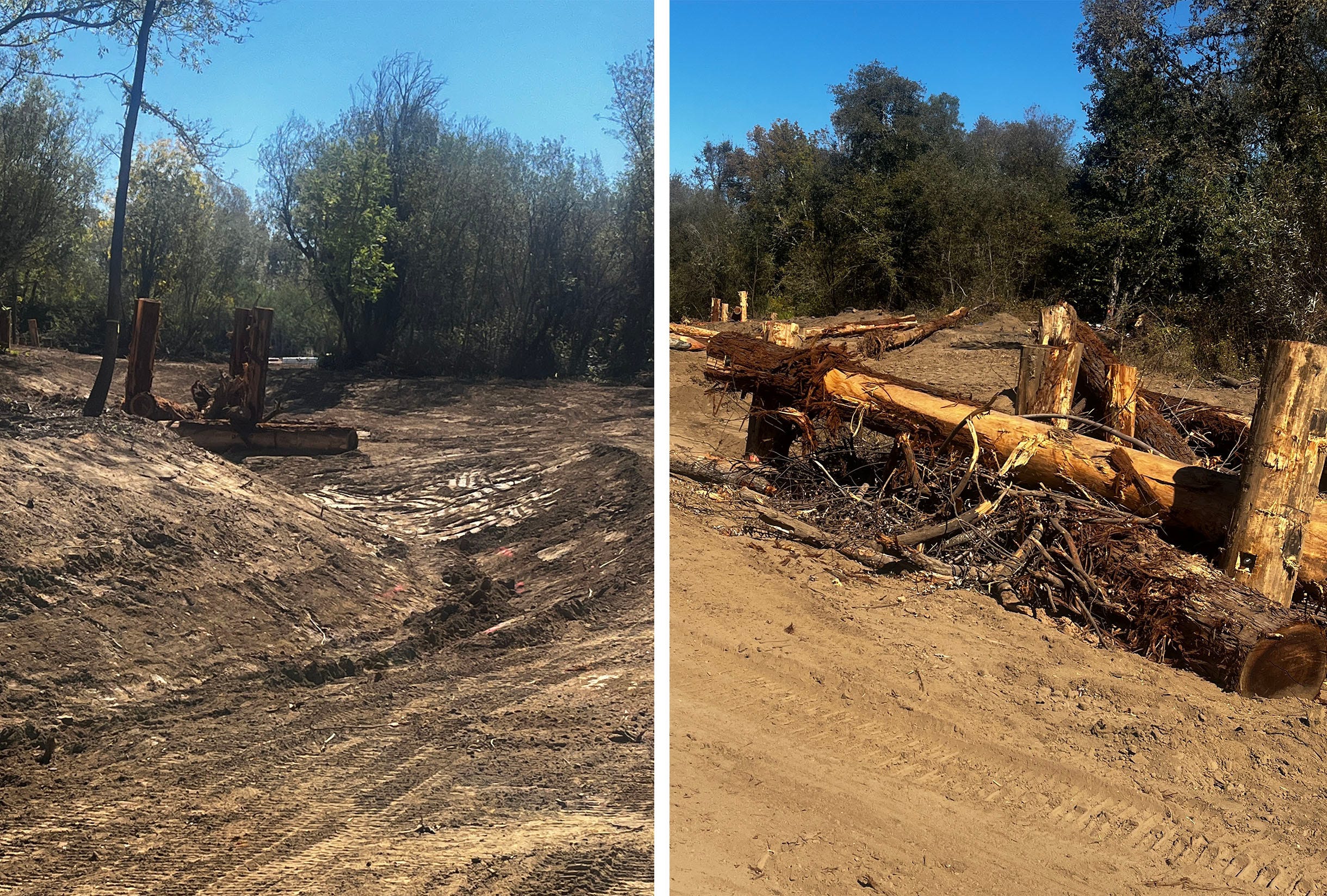
The hardware isn’t meant to last forever. “Eventually, those structures rot and this rusts, and it all goes away,” Green says. “By then, we have natural sources of wood. The creek is acting in a more natural way.”
After construction, a contractor will plant the site from a set plan, as at Iron Horse, with water-loving plants set into the bottoms of the new channels to jumpstart the revegetation.
“While I’m the project manager, this is really a partnership with our contractor, Hanford ARC, as well as the revegetation contractor, Triangle Land Management. It’s all very much a team effort.”
Two landowners, one project
Because Green Valley Creek runs entirely through private land, nothing happens without landowners willing to take part. Phase 2 spans two properties.
One belongs to Sweetwater Nursery, whose warehouse and greenhouse sit at the southern edge of the work site. Gold Ridge approached the nursery years ago, and its owners were interested. The district then went through the lengthy design process, ensuring the nursery owners understood and were comfortable with the plans.
The neighboring parcel took a different path. Its previous owner had declined. Partway through the design process, the property changed hands, and the new owners were interested in participating, which more than doubled the size of the eventual project.
That kind of support is the foundation of every project Gold Ridge builds. “The fact is, they’re essentially donating acres of their property to help restore fish populations,” Green says.
Bigger machines, bigger budget
The sheer size of the newest project is awe-inspiring. It is the larger of the two projects. Iron Horse moved about 13,000 cubic yards of earth, with a construction contract of about $2.6 million and a total cost of roughly $3.5 million to $4 million once studies, permits, monitoring and oversight were included.
This time, Green says, the crews are moving more dirt, placing more wood and doing more planting. He estimates the cost will run at least half a million dollars more than Iron Horse, with construction cost escalation adding to the bill.
The equipment shows the project’s scale. Three giant haulers worked on the site prior to this interview, and one will remain until the project is complete. Each hauler can carry 25-35 cubic yards of soil, and none are street legal. Three excavators, a water truck, smaller machines, and a team of hand laborers round out the crew.
The funding comes from the same sources as Iron Horse. Gold Ridge’s 2023 NOAA grant was written to cover both projects, and a separate Department of Fish and Wildlife grant covers the rest. Together, Green says, the two grants fund the entire project, from construction through revegetation. That is a welcome contrast to last year, when potential federal funding cuts nearly derailed the Iron Horse project in its final months. This time, the money was in hand from the start.
Next: the S curve and Atascadero
The question Green hears most is how Phase 2 ties into the S curve, where Green Valley Road crosses the creek just upstream. The answer is that it doesn’t, at least not directly. The S curve will be a separate project in the same series, with a different set of problems.
There, the creek runs across an alluvial fan rather than a low, flat floodplain, and sediment piles up in the channel until it loses its capacity. When the creek floods over the road, it carries juvenile fish out into the neighboring vineyard, where many become stranded. Department of Fish and Wildlife crews now routinely rescue fish from the vineyard after high water.
About 10 years ago, the creek jumped its channel at the S curve, and Sonoma County Water Agency dredged several hundred feet of it to reduce flooding. Afterward, Gold Ridge joined agency biologists to fish out the channels that had formed in the vineyard. They found hundreds of juvenile coho. “We’re losing an endangered species every time the road floods,” Green says.
The flooding also sends sediment through the vineyard and into the Atascadero Creek wetland, where the land flattens, and the sediment drops out. Over time, it has built what amounts to a dam. The wetland behind it, once seasonal, now holds water year-round, a change Green says has happened within the last 25 years. Drivers on Green Valley Road can see the standing water today.
That Atascadero wetland also has water-quality problems. After a big storm, dissolved oxygen spikes, then falls sharply as flows drop and vegetation respires and decays. The challenge, Green says, is keeping the wetland intact while providing it with a channel of moving water so fish can survive their time there.
The plan is a series of projects over roughly the next decade. A sediment management area near the S curve would keep some human-caused sediment from moving downstream. Another project would address the buildup at the bottom of Atascadero. Gold Ridge is working with the county, landowners near the S curve, the Department of Fish and Wildlife, which owns much of the lower Atascadero wetland, and several landowners farther up Atascadero Creek.
The goal is to open a path through the wetland complex to Atascadero’s headwater streams, which keep flowing year-round and offer good spawning and rearing habitat, something Upper Green Valley often lacks in dry months. “We’re kind of working our way upstream,” Green says.
The amazing thing is that all this massive construction, including installing erosion-control fiber, laying down seemingly miles of straw wattles, and planting vegetation, is planned to be completed by the first of November. When asked whether El Niño would make a difference, Green said that once the project is in place, it is not going anywhere and can only help.
In the end, he says, the work is about more than two fish species.
“We’re designing and building these projects with the idea that we’re restoring ecological processes,” Green says. “Those processes have been in play here for millions of years, and all of the wildlife and the vegetation evolved with them. It’s ecological restoration. And that improves the health of the entire watershed.”
* According to Wikipedia, “a forb is a herbaceous flowering plant that is not a grass, sedge, or rush.”

Sponsored Content
Homebuyers Discover Sustainable Living and Thoughtful Design at The Canopy in Sebastopol
Developed by City Ventures, an award-winning builder known for its solar-powered, energy-efficient homes, The Canopy presents a brand-new collection of eco-friendly, craftsman-style townhomes to the area—and homebuyers are taking notice. With six versatile floor plans and a premier location, the neighborhood offers a smart option for those looking to put down roots in an area that supports long-term home value. Features include ADUs, elevators, flex spaces, decks and patios. Community amenities include a meditation garden, relaxation lounge, playground, and walking paseos. Located within a highly regarded Sonoma County school district, The Canopy also features all-electric construction, owned solar panels, and smart-home tech. Homes are selling quickly.
Address: 102 Honeycrisp Court, Sebastopol, CA.
Details & directions, visit: CityVentures.com/The-Canopy